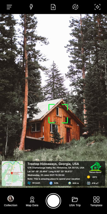
Add geotags to your photos
GPS Map Camera: Geotag Photos Add GPS Location is a free, innovative multimedia app designed to enhance your photography experience by adding comprehensive geotag information to your photos. This information includes date and time, live maps, latitude and longitude, weather, compass direction, altitude, and even magnetic field measurements.
GPS Map Camera: Geotag Photos Add GPS Location’s setup process is straightforward: install the app, open the camera, select from advanced or classic templates, and configure the settings to suit your preferences. Once set, the app automatically adds geolocation stamps to photos, so you don’t have to worry about tweaking advanced settings.
Comprehensive data in one photo
One of the app's standout features is its extensive customization options. Users can choose from various map types and add addresses, GPS coordinates, date and time stamps, time zones, logos, notes, hashtags, and even a range of weather and environmental data. This level of detail can be particularly useful for travelers, real estate professionals, and bloggers who need to document their experiences with precise location data.
The app also offers a custom GPS camera that allows users to tailor their photography experience to their specific needs, whether they're capturing scenic landscapes or documenting important events. However, GPS Map Camera is not without its drawbacks. Users have reported difficulties with zooming and focusing, which can be frustrating when trying to capture detailed photos. Additionally, keeping the location services active can quickly drain the phone's battery and cause it to overheat.
Another significant issue is the intrusive ads, which can obstruct parts of the app and make it challenging to click on certain buttons. This can be particularly bothersome when trying to quickly capture or edit photos on the go. Despite these challenges, GPS Map Camera: Geotag Photos Add GPS Location offers a unique and valuable service for those needing detailed information on their photos either for documentation or personal purposes.
Could be better with a few tweaks
Although the GPS Map Camera: Geotag Photos Add GPS Location app has a couple of performance and usability issues, its extensive features and customization options still make it a worthwhile app for those looking to enhance their photography with detailed geolocation data. With some improvements, it has the potential to be an indispensable tool for documenting and sharing travel experiences.